HIGH SAFETY ALERT!
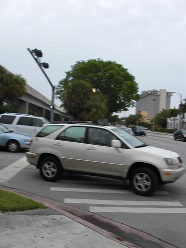
Although it looks complete the new traffic island at SW 57th Avenue (Red Rd) and US -1 has a 4-6" wide channel cut about 6-8" deep on either side between the newly poured curb/ramp and the existing road surface. THIS IS EXTREMELY HAZARDOUS for bicycle riders, joggers or even pedestrians. The cut is not marked in either direction and is at an angle to the pedestrian crossing so could easily capture the front wheel of a bicycle. WALK bicycles across this intersection until it is repaired properly.
ANOTHER SAFETY ISSUE
The pedestrian crossing signals at SW 27th Avenue and US-1 were not operational this morning (12/29)
Monday, December 29, 2008
Thursday, December 4, 2008
Good Weather to Ride and Some Progress
Back on the M-Path after a few weeks of travel and allergy stuff. Some observations:
- The South Miami intersection at Sunset Dr (SW 72nd St) is complete and nicely done. Nice signalization and clear crossing marks.
- New construction at the Red Rd (SW 57th Ave) intersection. No warning...you are in the intersection before it is obvious that a new median is under construction. BE CAREFUL!
- The sidewalk to path transition at Douglas Rd (SW 37th Ave)has been completed. Work on the adjoining sidewalk to the north continues...GO SLOW!
- The dangerously broken chainlink fence at the 27th Ave intersection has been completely removed...THANKS to M-D Transit?
This weather is great for commuting to work. The best areas of the Path are looking very good: Coral Gables in front of UM and through "The Roads" closer to Miami are the best...very relaxing.
Wednesday, October 1, 2008
Along the Path
Riders beware: The intersection of Sunset Drive and US-1 continues to be impassible for bicyclists and pedestrians due to reconstruction of the sidewalks and islands on the west side of the intersection. This has been on-going for about a week and probably has another week to go. A little consideration for M-Path users would have been nice, but in lieu of that I suggest you you detour using SW 62 Ave and SW 70th St.
Another salute to the grass trimmers working on the Path in the Gables between Lejeune and the new Ponce circle who were courteous enough to park their truck off of the paved pathway. Thanks guys.
Another salute to the grass trimmers working on the Path in the Gables between Lejeune and the new Ponce circle who were courteous enough to park their truck off of the paved pathway. Thanks guys.
Monday, September 22, 2008
Right on Red to US1: Suicide or Manslaughter?
Here's an easy fix that may help cyclists and motorists as well, a "two-fer".
SW 16th Avenue's intersection with US-1 is a "T"-type. There is no continuation of 16th Ave east of the Highway. The roadways are signalized but the crossing is not.
There is a sign hanging above the roadway facing 16th Ave which reads: "Right Turn On Red From Right Lane Only". And yes, there is second southbound lane on 16th Avenue so in order for a motor vehicle to turn right on red a driver in the right lane would have to :
- nose his vehicle out far enough to see around the vehicle next to him in the other lane
- to gain the required visibility to the high speed traffic coming south on US-1 he/she would by necessity have to cross the stop line and completely block the striped crossing
- because of the continuous southbound US-1 traffic during most of the day the entering driver could not afford to take his/her eyes off of the line of traffic and would therefore NEVER see a bicyclist or pedestrian approaching from the south on the M-Path
So by permitting this turn the vehicle driver is forced to break the law in order to even make an attempt to enter the traffic flow without signalized assistance. Look, what's the chance of making a safe merge onto a busy US-1 anyway? Why not use some common sense and replace the sign with one that says: "No Right On Red"?
There are other intersections with permitted right-on-red turns to Southbound US-1 along the M-Path. Who needs them? They are inconsistent and dangerous to drivers and M-Path users alike. I urge the County, City (who does have the authority?) to prohibit these turns all along the Path, BUT LET'S START AT SW 16th AVENUE!
Appreciative nod to the grass cutting crew working along the Path in the Gables this morning. They courteously parked their truck off of the pavement.
Friday, September 19, 2008
I'm A Traitor
Recently, I was at a Saturday Critical Mass ride, and I was telling someone about how I take the M-Path home from work everyday. He was telling me that he didn't like the M-Path, because it's hard to gain any speed, and that he takes Ponce instead. After a while I decided to give it a try, and I have to admit, it's not too bad, and I definitely dropped my commute time by about 5 minutes. The reason I bring this up is because it is part of a larger cycling debate that many of us are aware of. Basically, separate cycling facilities are important. Versus, as long as we practice the principles of vehicular cycling, separate infrastructure is not necessary. The problem with this debate is that it is usually carried out by cycling geeks, so they are not incorporating the mindset of the average commuter or pedestrian into their argument.
As someone who became a cycling commuter within the last year, I still retain some perspective of a non-cyclist. I can now get home easily from South Miami to downtown without setting wheel on the M-Path, but I can say with complete certainty that without the M-Path, I would have never attempted to commute to work on my bike. The M-Path gave me the confidence and skills to brave the streets. Furthermore, not all cycling is about going from point A to B in the shortest possible time. Sometimes we just want to go on a nice relaxed ride without cars whizzing past, and when that's the case, I still hop on the M-Path, so I can smell the flowers as I ride.
A 'Thanks', GMN debrief
Hank previously highlighted a frequent problem involving vehicles parked smack in the middle of the path. The usual culprits in my experience are landscapers and FP&L, and wanted recognize this Miami-Dade Transit van to illustrate my point. Thanks to the driver for the courteous display, whoever and wherever you are. Sometimes it's the little stuff that counts, and it is appreciated.

Re: Tuesday's Green Mobility Network meeting

The turnout was fantastic - JHop is claiming around forty - but even more exciting was the draft of the Bicycle Action Plan for the City of Miami. Though the M-Path is the County's domain, several bike lanes are now in the works that would intersect the path.
I will wait for the finalized plan to dive into specifics, but key East/West lanes seemed priority on the presented draft. This is both an exciting and critical moment for improving the bicycling infrastructure in South Florida. Though Mayor Diaz was a no show, he dispatched staff members who adamantly proclaimed his intent to create the action plan and set it in motion.
Now, if not more than ever, the importance of the M-Path is visible as a potential main artery for bicycling traffic south of the downtown area. For the sake of connectivity, it is absolutely imperative that the county cooperate with the City of Miami and respond to our initiative.
Finally, A big shout out to Mike Lydon from Transit Miami who worked very hard on developing this action plan alongside city staffers - and took the time to patiently go over the draft with everyone at the meeting.
Monday, September 15, 2008
GMN Meeting This Tuesday

The Green Mobility Network, quite possibly the solution to the rusted, clunky drive train that is South Florida's bicycling advocacy, will hold a meeting tomorrow night near downtown Miami.
There are all sorts of reasons you, the concerned cyclist and/or pedestrian, should attend. One is to take a sneak peak at portions of the inaugural Bicycle Action Plan for the City of Miami, drafted by city staffers and volunteers. Another reason to go is to network with like-minded cyclists/pedestrians and check out some good opportunities to find ways to do your own advocating (other than just riding and yelling at distracted drivers, of course).
I've attended a few meetings and the draw is usually very diverse, spanning all types of citizenry and everyone is very approachable. So don't be shy.
Place: Garden Center @ Simpson Park
Time: 7:30PM, Tuesday, September 15
Spoke's has the details.
Wait, wait, wait - bicycle, action, plan, AND Miami... all in the same sentence? If you didn't just fall out of your chair, you need to wake yourself up.
May your track stands be lengthy,
tony
Thursday, September 4, 2008
Back In Town
I've been back on the M-Path this week after almost two months away with only a few days in Miami during that time.
Some observations after my first couple of rides:
Some observations after my first couple of rides:
The new paved path from the north end of the South Miami transit station to the controlled crossing at US-1 and SW 70th St is nearly complete. CONGRATULATIONS to Miami-Dade Transit for this improvement to safely lead users of the M-Path and station to and from this crossing point.
But what's the new fence and gate all about?

Will this portion of the otherwise open station be closed at certain times? If so, why and how would M-Path users know?
Also, because of the gate installation at the south end of the new pavement it remains very narrow where it joins the old path. So the old blind corner has not been substantially relieved. Why not lose the gate and make the intersection of the paths wider?
Yesterday there were 2 grass cutting crews working along the Path. Neither was blocking the pavement, a very good thing. Today there was another and, you guessed it, smack in the middle! I politely asked if next time the truck could be parked on the grass and was politely received. But wouldn't be easier to simply have a "no blocking" requirement for any contract or other maintenance work on or around the Path?
The work on the condominium constructuion at SW 1st Rd, south of Broadway has at least temporarily given back the street. No need these last few days to detour to S Miami Ave, although the resurfacing of Broadway has caused some resourceful re-routing. That should be completed by the end of today.
More later.
Wednesday, August 20, 2008
Who's the Man With the Master Plan?
Contrary to what Dr. Dre would have us believe, the man with the Master Plan is actually Miami-Dade County. The M-Path Master Plan was created in July of 2007. It's a 46 page pdf document, so I can understand peoples' unwillingness to read it in its entirety. I did read it, and I was encouraged by the fact that the creators of the plan seem to have a very solid grasp on the problems that plague the path, and are offering many of the same solutions we have talked about here.

 Signage will be used to increase safety and establish an M-Path identity. Users can expect to see MUTCD bicycle road signs depicting the letter M rather than the more common number (Venetian Causeway's signs have a V as well). These signs will also have mile markers, and direction of travel. Pavement markings will also be used, including directional, information, approaching pedestrian areas, and instructions on how to safely navigate corners (as seen on the image to the right). For cross traffic, bicycle crossing signs will be installed 250 feet before all crossings.
Purpose of the Master Plan
To address the problems facing the M-Path, and to develop a plan correct those problem areas, and to apply the same thinking to future extensions. This will be done by developing uniform standards, so areas of the path will not be looked at individually, but as part of a whole. The goal is that by applying uniform standards the M-Path will develop an identity.
Problems
- Substandard design
- Poor visibility
- Missing trail segments
- Lack of trail continuity and connectivity
- Encroachment of trail
- Deteriorating pavement conditions
The Standards
The path will be be widened to 12 feet to allow for safer two way traffic as well as higher rates of speed. Intersection crossings will be made more visible by adding brightly colored paint, and will continue to be 12 feet wide. When appropriate, the crosswalk will be raised to further increase visibility, and encourage slower cross-traffic. Refuge islands will be installed at crossings that are multi-step processes. Like the Bird Road example given below.

(see the Master Plan for more mapped improvements)
 Signage will be used to increase safety and establish an M-Path identity. Users can expect to see MUTCD bicycle road signs depicting the letter M rather than the more common number (Venetian Causeway's signs have a V as well). These signs will also have mile markers, and direction of travel. Pavement markings will also be used, including directional, information, approaching pedestrian areas, and instructions on how to safely navigate corners (as seen on the image to the right). For cross traffic, bicycle crossing signs will be installed 250 feet before all crossings.
To increase safety, emergency call boxes will be added, along with more lighting for nighttime rides. Fencing may also be used in certain areas, or landscaping alternatives, and railings where there is a drop off larger than two and a half feet.
Development Phases
Short term development; resurface critical areas, repaint crosswalks, pavement markings near intersections and metro stations, realign M-Path at South Miami Station (mission accomplished), construct missing links at UM parking lots, emergency call boxes, encroachment measures, pedestrian bridge over Miami River (just kidding), and directional signs with milepost information.
Long term; widen to twelve feet, countdown pedestrian signals and other crosswalk reconfigurations, lighting, non-motorized bridge at Coral Gables Waterway, and provide wayfinding at metrorail station plazas.
Funding will come from MDT, MDC, and FDOT. Some of the cost estimates include 1.5 million for resurfacing and realigning the entire M-Path. The short term development would cost $685,00, and the long term development would cost $2.5 million
Conclusion
They seem to be very serious about making these improvements. Anyone who reads the Master Plan can see that there was some serious thought put into it. They are fully aware of the problems facing the path, and they have posited very legitimate solutions to those problems. I also believe that the only way these plans get enacted is if the path is perceived as being useful and used. We can't take a Field of Dreams mentality here. We have to come so they will build it. The more people using the M-Path, the more incentive the county has to improve it.
Sunday, July 27, 2008
Crosswalks of Doom
For anyone familiar with the M-Path this is a familiar and dangerous sight; Cars blowing right through crosswalks making right hand turns (or more likely, camping out there, because the traffic on US 1 is so thick that they'll never get to turn anyway) despite the fact that bikers and pedestrians having the green light. You would think threatening signs like this:
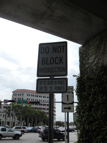
might discourage people from jeopardizing the lives of self-propelled commuters, but they do not. There are two reasons for the signs' lack of efficacy; (1) Lack of enforcement. I have never seen anyone getting a ticket for blocking the box, nor heard of it. (2) Lack of visual impact. The signs tend to blend into the background (signs signs everywhere there's signs).
I would love to see a bicycle policeman patrolling the M-Path. Police officers in cars don't seem to have any interest in enforcing that law, and logistically, it would be hard for them to do. But, a bicycle cop armed with a digital camera would be well equipped to enforce this law. Plus, think about the revenue that would be raked in until drives came to their senses.
We may or may not get bike cops making the M-Path safe for us all, but fortunately the M-Path Master Plan does have a solution for increasing the visibility of the crosswalks.

I think the visual impact of the ladder style, green crosswalk will help drivers become more aware that there are other people on the roads besides themselves.
Until these solutions are enacted we are on our own. We all want safer biking conditions, but none of us want to be martyrs for them. So please remember, when you see some jerk in the crosswalk blocking your right of way, just let him pass. Don't risk it. Remember why we commute by bike. It's more enjoyable than commuting by car. That driver is blowing through the crosswalk, because he's miserable on his commute home. We're not. We're on bikes, and we are happy.
Friday, June 27, 2008
M-Path Irony
Even though I take the M-Path home from work almost everyday I had never taken it much further south than Sunset Drive. Because I want to document all of the M-Path's problem areas, I had to acquaint myself with the M-Path's southern tip, and since I had never ridden that portion of the M-Path before, I thought it was a good opportunity to view the path from the perspective of someone who's new to the path. So after work, instead of heading north, I went south. Despite a couple of confusing forks in the path it is a nice scenic little jaunt. It even has a quaint little wooden bridge, but shortly after crossing the wooden bridge I found myself stranded at 67th AVE.
After becoming even more helplessly stranded upon encountering 878 I came to the sad conclusion that I had indeed reached the end of the path.
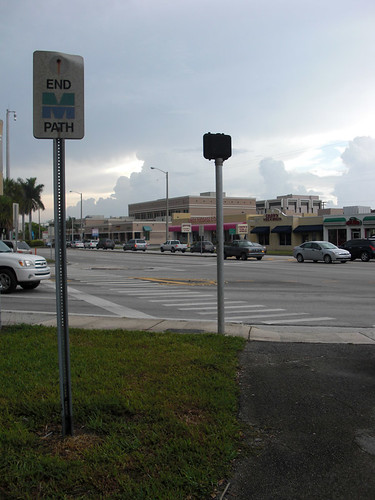
Yet, when the path truly ends, there is no sign in sight. Not that it would really matter considering the "End M-Path" warning is the "Boy Who Cried Wolf" of the sign world, but it does emphasize how silly, pointless, and confusing those signs can be.
Despite having no crosswalk to assist me, I soldiered on. After risking life and limb crossing 67th AVE in search of the rest of the path, I happened upon a dirt trail. "Is this the M-Path?" I wondered.
After pondering the unceremonious end of the M-Path I became equal parts amused and annoyed as I realized there was not a sign indicating that the path had ended. By my estimation, there are about 957 signs along the M-Path, falsely indicating it has come to an end. Like this one
South Miami Metro Station
Part of the M-Path Master Plan includes improvements to the approaches to the S Mia Metro Station. This week it appears that that work has begun. The work at the north end of the station will be especially helpful since it will reroute the path from tricky little section to the west of the firehouse and re-direct Path traffic directly to the signalized intersection at SW 70th St and US 1.
Monday, June 16, 2008
Monday 6/16/08 Update
Greetings,
Referring to the previous post, construction is continuing on SW 1st Ave just south of SW 15th Rd. The road is closed both ways and you can guess where traffic is redirected to... the M-Path, of course.

It's advisable to avoid this section altogether (one block east, South Miami Avenue has new bike lanes between SW 15th & 26th) or approach with extreme caution. Riding in this morning, the individuals responsible for flagging traffic were sitting in the shade enjoying a meal while cars drove up and down the M-Path unhindered.
As always, feel free to let us and others know about similar problems.
Be safe out there,
Tony
Wednesday, June 11, 2008
CONSTRUCTION TODAY
For those of you who usually ride parallel to the M-Path on SW 1st Ave note that that road is blocked in front of the new construction site, just north of the I-95 overpass. Might as well stay on the M-Path today and dodge the tree roots along this section.
Friday, June 6, 2008
Tony and the Pit of Doom (A Tale of Progress)
It's summer time! So between the sweaty arm pits (don't forget to pack that deodorant stick) and endless hurricane-preparedness campaigns, I thought I'd share a little story of hope from last year.
During one particularly spirited ride home from Downtown Miami, I crossed Alhambra Circle Road (in front of the U of M). If you've ever trekked through this area you probably noticed that the transition from crosswalk to sidewalk to parking lot (a conduit of the M-Path in this instance) is a bit disjointed on the southern side. The only way to avoid the curbed drop into the parking lot is to cut through a small grassy patch near the crosswalk signal.
It's no big deal, but I ride a road bike with skinny tires and my curb-hopping antics are reserved for special occasions. I crossed the street with a bit of momentum and detoured through the grass like I normally would, except I veered a little to the left for some inexplicable reason and found myself descending into the eternal pit of darkness. OK, it was only a hole about one-foot deep, one-foot around and just my front wheel went in - but the interaction of gravity and momentum resulted in a glorious face plant in clear view of rush hour traffic and a handful of UM students. If someone had it on video, the manuever would undoubtedly vault to YouTube greatness.
After a couple of indirect F-bombs that only added humor to the situation, I calmed down and found the hole. I put my foot in it. My foot was now completely hidden in the grass. The thing was completely invisible even standing in it.
Maybe it was because I grew up falling out of trees or something, but somehow I managed to escape relatively unscathed. The same grass that hid this demonic bike trap saved my face, but I stewed at the thought that this damned hole was perfect for swallowing a bicycle tire or an ankle.
After a quick adjustment to the handle bars (always carry a multi tool, kids) I made it home and plopped down in front of my computer, pompously reeling in dismay that such a landmine could exist along MY homeward commute. I found the complaint form on Miami-Dade Transit's website (see contact info). My initial response was not a cheerful one. I decided to sit on it for a few hours before submitting it.
Later that night, I rewrote it from a non-inquisitor's perspective. I concentrated on not sounding like a crazed maniac foaming with disgust and tried my best to express how this thing could do some damage. Someone may actually decide to read it, I figured, so why not. If I sound relatively sincere, something might get done.
In all honesty, I never expected to hear of it again. My only motivation was to say I tried. The thought about making a "China - This Way" sign to stick over it intrigued me, but I would give the county a shot first. I clicked send and imagined the complaint spiraling down a dark, never ending hole of its own.
Why the pessimism?
I, like many fellow Miamians, tend to hold the view of our local government and its departments as "the glass is not half-full, somebody drank it and chucked it against the wall". It seems that Miami has a long way to go as a large-scale metropolis in providing service and basic functions of government to its citizens.
Then my phone rang.
I received a phone call from a Mr. Reynold Monestine of Miami-Dade Transit (again, see contact info) about two days after my submitting my little incident report. His department received my complaint and he wanted to schedule a meeting at the site as soon as possible. After looking around in a mystified state for several moments I realized no, I'm not asleep, and set a date.
The next week I met with Mr. Monestine at Alhambra Circle Rd and showed him the hole. I even posed for a photo while standing in it. As the Property Manager for MDT, he was genuinely concerned and said he'd get it taken care of.
That he did. Though I recommended a ramp be installed in the sidewalk to provide a smooth transition to the parking lot, I knew it was a long shot. The immediate (ahem, cheaper) remedy was to fill the hole with dirt packing the hole and making it visible to pedestrians/cyclists.
Was it a final solution? No. Is it a big deal? Kind of. The small ramp from the sidewalk would be the way to go, but this did make it at least a little safer. Baby steps, people. This an example that people on the "inside" do exist and are listening to our concerns. If you're out and about, see something dangerous or have some sort of incident, report it. Communicate as well as you can and see it through.
If nothing gets done, be persistent. Once there is progress, thank those responsible. They need to know we're out there and Miami-Dade County officials and employees need to know we care that they care.
Friday, May 30, 2008
Updates
Greetings,
A big thanks to everyone who has given us feedback in the first week of our project. As you can see, we're working on organizing stuff and gathering data to make this as user-friendly as possible. We love suggestions or comments in general, so feel free to let us know what is on your mind.
If you haven't done so already, we urge you to review the M-Path Master Plan (yes, there actually is one!) drafted in 2007. It provides some good insight in regards to many issues cyclists and pedestrians deal with, including:
• Trail user safety
• Missing trail segments
• Lack of trail continuity and connectivity
• Deteriorating pavement conditions
• Poor visibility
• Encroachment of the trail
• Substandard design
• Limited signage
• Trail identity
The report can be downloaded here (.pdf): http://www.miamidade.gov/MPO/docs/MPO_mpath_master_final_200707.pdf
Look for a brief review in the coming days.
There are many meetings, plans, and events scheduled for the near future that could impact the M-Path and the overall state of bicycle-friendly infrastructure in Miami-Dade County. Now is certainly an exciting time to get involved and we hope that you stick with us.
So stay tuned - unlike the homeless guy I saw sprawled out in the middle of the M-Path today near 57th Ave, we're not going to sleep on this one!
Thursday, May 29, 2008
Recommendations for M-Path Improvement
This is our ongoing list of suggestions for improving areas along the M-Path. As it grows, we hope it will serve as a starting point for developing the M-Path into a safer, more conducive medium of transportation. Feel free to share your comments below.
Recommended improvements and repairs, ranked 1,2 or 3 [post date/transmit date/safety priority(1=highest)/1st cost category(1=lowest)/ongoing cost category(1=lowest)/fixed date]:
General: Every pair of Metrorail columns should be numbered from the start of the M-Path downtown. This would allow riders to know where they are in case of emergency or in the event they wish to report a maintenance item [5-22-08/_______/1/2/1/______]
General: Signs should be posted frequently reminding users to report maintenance issues to a central number easily accessible from a cell phone, like 311 for example. The chosen call center should be equipped to forward maintenance calls to Miami-Dade Transit [5-22-08/_________/2/1/1/_______]
General: Metro Rail contractors and maintenance personnel should be instructed not to park vehicles or equipment on the paved surface. They should also be required to post “work in progress ahead” signs sufficiently far from the work site in either direction so that Path users can be forewarned [5/29/08/________/1/1/1/_______]
General: ____________ should initiate a periodic (bi-weekly?) maintenance sweep during which broken glass is swept up, especially at intersections, and debris is removed from the paved pathway. In between routine cleanup excursions, there should be a response crew available to clean up reported dangerous conditions [[5-22-08/_________/1/1/3/_______]
General: There are several “End M-Path”, “Begin M-Path” signs currently installed at some, but not all, cross streets. These are confusing and unhelpful. Assuming they have been placed for some legal liability reason, they should be replaced with more useful signs such as: “M-Path continues 50 feet ahead” or “M-Path continues on other side of intersection” and then “M-Path continues here”. Begin and End signs should be reserved for the ultimate start and finish points. [5-22-08/_________/2/1/1/_______]
General: Warning signs should be placed along the M-Path at bicycle riders eye level to help anticipate difficult or dangerous areas. For example: there should be a warning sign before every intersection, in both directions: “Intersection Ahead, Slow Down”. Also, since the path weaves in and around Metrorail supports and other obstacles, upcoming curves should be indicated with appropriately drawn arrow signs, as on curved highways[5-22-08/_________/1/1/1/_______]
General: Broken pavement due to tree roots is a current and probably on going problem. These are dangerous to bicyclists at all skill levels. The path should be surveyed and the worst areas repaired promptly. There are other areas of pavement broken by other causes which should be repaired as well. [5-22-08/_________/1/3/2/_______]
Metrorail Stations: The current M-Path signage currently does provide clear instruction as to how users are supposed to go through or around the stations, and each one is different. The approach to each station should be marked with a large information sign, perhaps with a graphic showing the preferred route to the other end of the station. As riders approach the station there should be closely placed and clearly marked signs showing where the rider is supposed to go. In some cases the M-Path users may have to use the bus drive-thru, which should be striped, but signed to warn riders to “yield to bus traffic”. In other cases riders may have to cross the pedestrian plaza, and bicyclists should be instructed to “yield to pedestrians” [5-22-08/_________/1/2/1/_______]
Intersections (Users): At the approach to most intersections the M-Path pavement splits in two directions, but there is no indication as to which direction a rider should take for the safest (preferred) crossing. The intersection warning sign (#5) should have an add-on arrow which directs riders to the preferred crossing point[5-22-08/_________/2/1/1/_______]
Intersections (Cars): Every intersection should be posted with a bicycle crossing sign. Perhaps an enhancement could be added that says (“Do not block crosswalk”) [5-22-08/_________/1/1/1/_______]
Specific: Mile___ (North of Red Road Intersection). Contact FPL and insist that the low-hanging guy wire, which could cause serious injury, be removed and relocated[5-22-08/_________/1/1/1/_______]
Specific: Douglas Rd Station. The short section between the new circle at Ponce de Leon and the station has extensive broken pavement. The Path should be resurfaced in this area [5-22-08/_________/1/2/1/_______]
Specific: Viscaya Station. Resurface the concrete section of the Path between the station and South Dixie Highway[5-22-08/_________/1/2/1/_______]
Tuesday, May 27, 2008
RESPONSES TO 1ST POST
We received some quality feedback from our first posts. These included a copy of Eric Tullberg's excellant and detailed review of the M-Path N, the subject of this blog. We are reviewing his information to see how it could be incorporated. In the meantime our cue sheet has been updated with a bit more detail and we think what we have so far is consistent with Eric's study.
Ride carefully, tailwinds
Ride carefully, tailwinds
Wednesday, May 21, 2008
MP2E goes live, Ride of Silence, M-Path after dark?
We're up and running, er, riding. In the coming days and weeks this blog will be fine-tuned and updated to become a valuable resource for cyclists - and anyone else - who use the M-Path. Yep, it's a blog about a path. But, in my opinion, it is an important path. Our hope is to generate enough awareness that this utility path is actually one the best-established and bicycle-friendly routes in Miami-Dade County.
It certainly has its share of problems, however. With enough effort we believe it can be improved to become a great example of why Miami-Dade should embrace bicycles as a mode of transportation.
Side note - tonight is the Ride of Silence on Key Biscayne. It is a slow, silent 12-mile ride in honor of all cyclists who have been injured or killed by motorists. The ride is going in conjunction with many others throughout the nation. I will be there, and hopefully will grab a pic or two to share. Then it's off to the M-Path for the evening ride home. I've yet to ride the M-Path in the dark and it should be interesting.
Cheers.
Important Contacts
Important Contacts (note: we are constantly updating this list - please let us know who we've left out!)
Reynold Monestine
305-884-7529
rym@miamidade.gov
Property Manager
Miami-Dade Transit
Miami-Dade County Transit Complaint/Concern Form
Harpal S. Kapoor - Transit Director
Address: Overtown Transit Village, 701 NW 1st Court, Suite 1700, Miami, FL 33136
Phone: 786-469-5675
Mayor Carlos Alvarez
Stephen P. Clark Center
111 N.W. 1st Street, 29th Floor
Miami, Florida 33128
E-mail: mayor@miamidade.gov
Office of Commissioner Carlos A. Gimenez (District 7)
Downtown Office
Stephen P. Clark Center
111 N.W. 1st Street, Suite 220
Miami, Florida 33128
Phone: 305-375-5680
E-mail
District 7 Office
6330 Manor Lane, Suite 100
South Miami, FL 33143
Phone: 305-669-4003
West Grove Office
Frankie Rolle Center
3750 S. Dixie Highway
Miami, FL 33133
Phone: 305-446-3311
George M. Burgess
County Manager
Stephen P. Clark Center
111 N.W. 1st Street, Suite 2910
Miami, Florida 33128 E-mail:
Manager@miamidade.gov
Phone: (305) 375-5311
Reynold Monestine
305-884-7529
rym@miamidade.gov
Property Manager
Miami-Dade Transit
Miami-Dade County Transit Complaint/Concern Form
Harpal S. Kapoor - Transit Director
Address: Overtown Transit Village, 701 NW 1st Court, Suite 1700, Miami, FL 33136
Phone: 786-469-5675
Mayor Carlos Alvarez
Stephen P. Clark Center
111 N.W. 1st Street, 29th Floor
Miami, Florida 33128
E-mail: mayor@miamidade.gov
Office of Commissioner Carlos A. Gimenez (District 7)
Downtown Office
Stephen P. Clark Center
111 N.W. 1st Street, Suite 220
Miami, Florida 33128
Phone: 305-375-5680
District 7 Office
6330 Manor Lane, Suite 100
South Miami, FL 33143
Phone: 305-669-4003
West Grove Office
Frankie Rolle Center
3750 S. Dixie Highway
Miami, FL 33133
Phone: 305-446-3311
George M. Burgess
County Manager
Stephen P. Clark Center
111 N.W. 1st Street, Suite 2910
Miami, Florida 33128 E-mail:
Manager@miamidade.gov
Phone: (305) 375-5311
The Cue Sheet
The Cue Sheet is an ongoing record of areas we believe cyclists should pay extreme attention to. These are instances on the M-Path that can act as hazards if neglected. If you have any comments or additions to the Cue Sheet, feel free to leave us a comment. Once one of us gets around to checking it out, we'll add it to the sheet.
(Northbound from SW 67th Avenue & Southbound from SW 15th Street)
[Note: MR refers to the Metrorail structure]
Mile 0.3: There is a nice little wooden bridge across the canal. The approaches are partially obstructed visually so stay to the right at all times
Mile 0.4: There is a driveway from the doctors’ parking lot at South Miami Hospital to the southbound lane of South Dixie Highway. Watch out for the Docs leaving the lot on their cell phones and not paying much attention to their stop sign. There is a "X" warning sign northbound on the M-Path but no warning southbound.
Mile 1.0: At South Miami Station use the bus drop-off lane but stay to the left and stop for pedestrians crossing to and from the parking garage. Go slow and yield to buses.
At the North end, alongside the fire house, cross SW 70th Street carefully and pick up the sidewalk as soon as possible to get back on the Path.
ALTERNATIVE ROUTE THRU STATION: Ride slowly on the station plaza to the north end where a concrete pathway leads off toward the SW 70th St/US-1 intersection. The head-high wing wall along the west side of this pathway creates a blind corner, but once thru that there is a new direct path to the signalized crossing. The approach from the north is a bit easier to see things.
Mile 1.3: Immediately after crossing Red Road (SW 57th Avenue) the path curves to the left and then once under the MR swings back to the right. AT THIS POINT there is a dangerously low guy wire supporting an FPL utility pole that comes up from the ground on the right. Northbound: keep LEFT around this turn but watch for oncoming traffic, Southbound: keep RIGHT.
Mile 1.5: Opposite San Amaro Dr near Mark Light Stadium, the M-Path appears to end at the south end of the parking lot. Stay in the lot and work your way to the drive area closest to Dixie Highway. When you get to the north end (Mile 1.7) there is a dirt path about 4 feet long between the walk light pole and the traffic light stantion to get you to the intersection where you can wait for a Walk Light. This is one of 2 locations along the route where one must leave a paved surface and it is very short.
Mile 1.9: At the south end of University Station the M-Path delivers you to the pedestrian plaza and there is no good way around it. Ride slowly thru the plaza and yield to pedestrians. The Path resumes after the parking lot on the north side of the station.
Mile 1.9 to 2.9: There are some nice, long, well-maintained sections here in front of the UM and in Coral Gables. Enjoy!
Mile 3.3: The LeJuene Rd, Ponce De Leon, Grand Ave Intersection is “a bear” Use the Walk Lights and be patient.
Mile 4.2: At Bird Road there 5 lanes plus a seperate right turn lane to southbound US 1 and no pedestrian lights. There is southbound and northbound traffic turning west which makes the traffic light sequencing completely whacky so approach this crossing with GREAT CAUTION! This is probably the most dangerous intersection on the route. Heads Up! Some northbound riders prefer to cross SW 37th Avenue on the north side of the Douglas Rd station, then cross Bird Rd to SW 29th St, then east to 35th or 34th Avenue and south a short distance to the M-Path. This can be done southbound in reverse, but that involves an unsignalized cross of Douglas Rd at 29th St. Pick your poison!
Mile 4.3: On most of the Path when it crosses under the MR columns the pavement straightens out a bit before returning to the other side and makes some nice, gentle variations in the trip. However, in this section there are two places where the Path weaves in and out around a single column set. The southernmost of these requires a slowdown in order to negotiate the tight turn which returns quickly to avoid a utility pole guy wire. There are no warning signs. There is also some tree root damage to the north of this reverse turn.
The northernmost has a more relaxed return but we suggest a slowdown at both.
Mile6.3: There is a portion of the path that weaves west and then back east around 2 or three MR column sets in which the top surface of the pavement is literally crumbling. It looks like a previous resurfacing just didn’t work at all. Be careful of loose gravel on this short section, especially in the turns.
Mile ____: Traffic southbound on SW 16th Avenue is allowed to turn right on red. In order to do so, drivers in this lane must nose out across the stop line and crosswalk to look around cars in the lane to the left so that they can have a chance to view fast-moving southbound drivers on US-1. THEY ALMOST NEVER EVEN THINK TO LOOK TO THEIR RIGHT!. So if you are northbound on the Path at this intersection, do not proceed unless you have positive eye contact or the intersection is empty.
Mile 6.9: The pavement around Viscaya Station is severely uplifted and broken. Slow down here and if safe to do so, pick your way around the worst spots.
Mile 7.3: The Path continues north after crossing SW 25 Rd (Mary Brickell Place). But it is unsafe because of the broken pavement caused by the routes of the Mahoghany trees planted between the path and the street. Until this portion is repaired get off and ride alongside on SW 1st Avenue until the end at SW 14th St. It has a good road surface and not too much traffic.
You’re downtown now…no more help. Except if you need to cross the Miami River, the best bridge is at SW 2nd Avenue which has a concrete surface (no metal grate…it’s great!). The M-Path continues to the South bank of the Miami River but it's "dicey".
Mile 8.1: The M-Path is unmarked but runs on a narrow path to the east of the MR columns on the north side of SW 14th St. Cross SW 13th St (Coral Way) @ SW 1st Ave where there is a Walk Light. Tricky tight left turn on the sidewalk to pick up the M-Path. It's difficult to follow the Path between here and the start of the last section.
Mile 8.6: On the north side of SW 7th St their is an "M-Path Begins" sign. There is a short 3-5' unpaved section after the ramp and then the pavement begins. BUT DON'T GO TOO FAST because...
Mile 8.7: The M-Path ends at the south bank of the Miami River. There is no warning and no barrier. If you're heading north too fast, you could go for an unintentional swim.
Our Mission
The M-Path
This blog exists to inform the public about the M-Path, a little-known utility path of approximately 9 miles that runs underneath the Metrorail from SW 67th Avenue (Ludlam, South Miami/Pinecrest) to SW 15th Street (Brickell).
Who We Are
The contributors are cyclists who use the M-Path to commute to work. At present, we believe that the M-Path holds great potential to provide a healthy and eco-friendly alternative to driving. We are everyday people who work in the downtown Miami area and have, at one time or another, discovered that commuting by bicycle is much more enjoyable than utilizing the personal automobile. Unfortunately, we also discovered that Miami has very little bicycle-friendly infrastructure and remains largely unaware of transit alternatives.
Our Mission
Our goal is to emphasize the importance of the M-Path and it's potential to transform Miami-Dade county into a bicycle-friendly area.
Quite simply, we want to create a medium in which users communicate with one another about the current state of the M-Path, how it can be improved to accommodate alternative forms of transit (with an emphasis on bicycling), and the benefits/dangers associated with utilizing it. Further, we intend to regularly inform those responsible for maintaining and improving the M-Path of its hazards, issues, and possible solutions.
Assumptions
- The M-Path is an excellent asset to Miami-Dade County but is substantially under utilized.
- M-Path utilization could increase if the existing facilities were made more user-friendly and in some cases safer.
- All types of riders should be accommodated on the M-Path, including (but not limited to) recreational riders, commuters, and visitors.
- Use of the M-Path is by necessity a blend of traffic regulations, pedestrian protocols, and common sense.
- Bicyclists are most vulnerable to falls and other accidents when they are starting or stopping, the times when bikes are inherently less stable and riders are most distracted. Necessary starts and stops should be easily anticipated and made as safe as possible.
We welcome your suggestions about how to improve the M-path, safety observations, and your M-Path stories of Joy and/or Horror. Feel free to drop a comment to us in the appropriate post.
Subscribe to:
Posts (Atom)